Geotrek and GeoNature are two free open source solutions for the administration and exploration of French national parks. The solutions provide national park authorities with tools to support the management and monitoring of the parks’ flora and fauna, aiding the protection of biodiversity and ecosystems across France. For the general public, a record of the trails, activities and wild species are presented through interactive maps, to promote sustainable tourism and knowledge sharing.
Established in 1973 and after being a user of various open source solutions throughout the years, the Écrins National Park Information System division decided to join and contribute to the open source community with Geotrek and GeoNature. The reserve currently collaborates with various French national parks, having built a community of users and a governance model oriented toward further development of the tools.
Geotrek
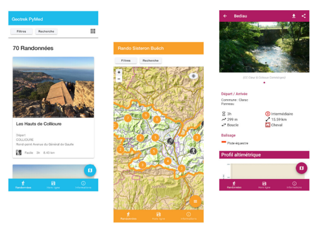
Launched in 2012 under the BSD license, Geotrek is an open source solution composed of a Geographic Information System (GIS) mapping tool, a website and a mobile application, for management and support to the development and preservation of the natural territory.
The development of Geotrek started as a cooperation between the Écrins National Park and the Mercantour National Park in France, under contract with the software company Makina Corpus. Later, the Alpi Marittime Nature Park joined the project, taking the solution across the border to Italy. As of 2022, close to 20 national parks across France have reused the code and configured their maps with data on the trails and activities.
The solution includes three components, all available on GitHub:
- Geotrek-Admin, for the management of the paths by the National Parks and Tourism organisations, with GIS features. The managing parties can draw and manage the hiking trails with sections and topological networks;
- Geotrek-Rando, web application for the promotion of activities, for search and display of the hiking trails within the national park. Users can filter the results based on activity, distance, difficulty, and other characteristics; and
- Geotrek-Mobile, for easy access to Geotrek’s functionalities on the go/while in nature (for both Android and iOS).
GeoNature
GeoNature is a suite composed of six different open source tools for the collection, management and distribution of wildlife data, and the administration of users and taxonomy repositories. Available with both desktop and mobile versions to facilitate the collection of data on the go, the purpose of this suite is to build a tool that presents updated information on all sightings of the local species spotted by the national park’s agents.
Created in 2014 by the Écrins National Park and released as open source, GeoNature served as the foundation for the Biodiv’Ecrins page. In 2017, the solution oversaw a restructuring that offered other national parks a simplified way to reuse the tool with their data.
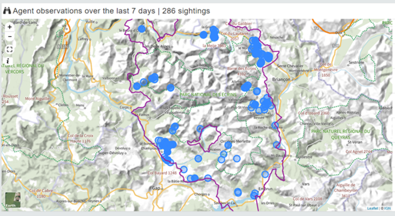
The GeoNature tools support the protocol-based approach of the solution for the construction and management of databases and maps. The protocols require detailed study plans that explain how data should be collected to address a specific scientific question, with rules for the sampling, the defined units, techniques applied and other variables such as frequency and weather conditions.
Through the maps, visitors can discover what species were recently seen in the area and historical data on the presence and movement of said species within the national park. The solution is currently used by 68 national parks and public organisations, with the Regional Nature Park of Normandy-Maine presenting the first observation records dating back to 1905.
Since launching both solutions, the Écrins National Park has organised several meetings with the user community to promote and discuss future developments of GeoTrek and GeoNature and present other open source solutions that cooperate with the tools. The projects provide environmentalists and tourists with the necessary resources to discover the protected areas while helping to ensure the preservation of the natural environment.