Description
The official catalog of addresses provides the management of the official street (of La Rioja) that currently does not exist, as well as the management of it from a cartographic perspective, decentralized and shared offering a reliable information base as well as the possibility of exploiting from said street map different optics from positions and spatial zones
The database of streets and addresses of La Rioja (#CallejeroDeLaRioja), is a project promoted and coordinated by the Government of La Rioja, with the active participation of the 174 municipalities in the region (Autonomous Community of La Rioja).
The objective is to define a database of streets and addresses of La Rioja, official and public, from the information provided by the municipalities, since these are the competent authorities to define the name of the streets and the numbering of the addresses .
To do this, the Regional Government has developed an application in an Oracle Spatial database, which allows editing the geographic and alphanumeric information of the streets and addresses in the cloud.
City officials can also edit their street from any computer, without installing any component.
For the municipalities that prefer it, interactive maps have been configured that show the street map. By clicking on the map, you can send a geolocated message to the project coordinators. An edit note that can be accompanied with an image. These notes are processed daily.
The procedure that is carried out in a browser does not require installation or other complements and, given its simplicity, it is not necessary to receive training.
Once the information on streets and portals has been reviewed, an interactive map is configured for the web of each municipality, using the Maps API of the Government of La Rioja (https://bit.ly/2C79kfk)
The maps contain a button to download open data in GeoJSON format, CC By 4.0 Int.
A map https://bit.ly/2C79kfk shows by municipalities the status of the project and allows access to interactive maps of the data that have already been reviewed and approved by their respective municipalities:
The stored data is also distributed through the WMS (Web Map Service) and WFS (Web Function Service) services:
https://ogc.larioja.org/wms/callejero/request.php?service=WMS&request=GetCapabilities
https://ogc.larioja.org/wfs/callejero/request.php?service=WFS&request=GetCapabilities
A geocoder has been developed, which allows locating the position of an address contained in the database: https://www.iderioja.larioja.org/geocoder/
The API offers direct, inverse and paired geocoding services, which allows the integration of geocoding processes in all types of computer applications, in order to standardize the management of address data.

Functions
-A starting from one direction, automatic positioning on the map, optimization.
-Facility and homogeneity in the captures of addresses in all information systems.
-Version of street (for searches, etc), reuse.
-Use of synonyms in the nomenclature of the streets, main street, etc ...
-Each police number with documentation attached to said portal.
-Possible massive exploitations (big data) of the information in different systems through the existing unique coding.
-Share said official street map with all public entities interested in their information systems. Reuse
-For the fact of having correctly codified the police number, automatic exploitation in cartography.
-Free tool for editing the lines of the vials on the map map itself.
-Exportable to another community, developed entirely with free software tools
-Bidirectional query Integrable with SOS, emergency systems, firefighters, Police, etc., with the street you have the coordinate and with the coordinate you have the street
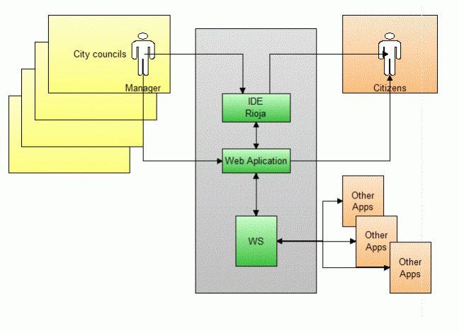
The architecture of the solution is composed of a set of modules that, thanks to the interoperability with the Official Cadastre and the Geospatial data system, allows any organization to exploit information from different perspectives. In addition to street management, it offers a set of WS so that information systems of any kind can link their physical addresses at the police number level with a location linked to the territory. Making it possible in this way to exploit different casuistics from said territorial location, for example incidence of a certain disease at the level of a polygon in the territory or at the level of a building.
- Street management: Decentralized at the municipality level, which allows the street information to be maintained at the moment and its availability at the moment for other delegated systems.
- Management of street versions, synonyms, etc., for consultation from obsolete names or parts of name
- Link with the Spatial Data Infrastructure of La Rioja
- Integration with the cadastral parcel of La Rioja
- From certain information of a street return of an IDE coding
- Disposition of the official street map of La Rioja to any interested citizen or information system
- System in the cloud for the municipalities of the Government of La Rioja that are responsible for the maintenance of their street.
- Completely developed with free software tools, both in its management and cartographic component.
As a result of the existing collaboration between the Government of La Rioja and the City Councils of this community, in the shared effort to build a homogenous Administration and under the premise of joining forces and sharing resources, commitments have been formalized to use the system in order to ensure the attainment of a reliable official street map, updated and available online at all times.
Once completed its full availability through Bigdata (innovation) cross-information can be collected from different management systems linked to each other through positioning with its territorial coding to obtain conclusions in many social, health, economic, educational, etc., linkage that currently does not exist.