The Malta Spatial Data Infrastructure (MSDI) portal aims at sharing environmental related geospatial datasets. It is part of the INSPIRE Directive infrastructure and offers web services to the general public, public service and public sector organisations. These can use the services to provide their spatial datasets to the public. The Development Planning Act is the Maltese legislation transposing the INSPIRE Directive.
The Malta Information Technology Agency (MITA) , the competent Authority for implementing the National Spatial Data Infrastructure in Malta, has developed the MSDI using mostly open source software. To ensure that the spatial data infrastructures of the Member States are compatible and usable in a Community and transboundary context, the Directive requires that common Implementing Rules (IR) are adopted in a number of specific areas, including metadata, data specifications, network services and data and service sharing.
Policy Context
Directive 2007/2/EC establishing an Infrastructure for Spatial Information in the European Community (INSPIRE) entered into force on the 15th May 2007. This infrastructure aims to support Community environmental policies, and policies or activities which may have an impact on the environment. INSPIRE is based on the infrastructures for spatial information established and operated by the 28 Member States. The Directive addresses 34 spatial data themes needed for environmental applications, with key components specified through technical implementing rules. This makes INSPIRE a unique example of a legislative “regional” approach.
To ensure that the spatial data infrastructures of the Member States are compatible and usable in a Community and transboundary context, the Directive requires that common Implementing Rules (IR) are adopted in a number of specific areas: Metadata, Data Specifications, Network Services, Data and Service Sharing and Monitoring and Reporting. These IRs are adopted as Commission Decisions or Regulations, and are binding in their entirety.
The Directive has been transposed into Maltese legislation under the provisions of the Development Planning Act and brought into force by Legal Notice 185, 2013. The Malta Information Technology Agency (MITA) has been designated as the competent Authority in terms of the implementation of the Directive and the National Spatial Data Infrastructure in Malta.
Description of target users and groups
Citizens, businesses and public administrations.
Description of the way to implement the initiative
Organisations that have a spatial infrastructure can share spatial data through this portal using a web map service. A web map service (WMS) is a standard protocol for serving georeferenced map images over the Internet that are generated by a map server using data from a GIS database. On the receiving end, the general public may:
- view the spatial datasets using online displaying tools,
- use the discovery service to perform online search for datasets based on metadata,
- request download of datasets that are available on the website through the download service.
The portal provides the following functionality:
- General information and resources related to the INSPIRE Directive;
- View services as a minimum, display, navigate, zoom in/out, pan, or overlay spatial data sets and display legend information and any relevant content of metadata;
- Discovery services search for spatial data sets and spatial data services on the basis of the content of corresponding metadata, and display the metadata content,
- Download services enabling copies of complete spatial data sets, or of parts of such sets, to be downloaded.
The portal seamlessly uses the eForms eGovernment platform’s workflow to process request for datasets. Depending on the usage classification of the dataset established by the data owners, the data can be used for academic, commercial and general use purposes. This website also forms part of the infrastructure for the INSPIRE legal obligations.
Technology solution
INSPIRE technical architecture
The following figure provides a simplified overview of key elements in the technical architecture of INSPIRE.
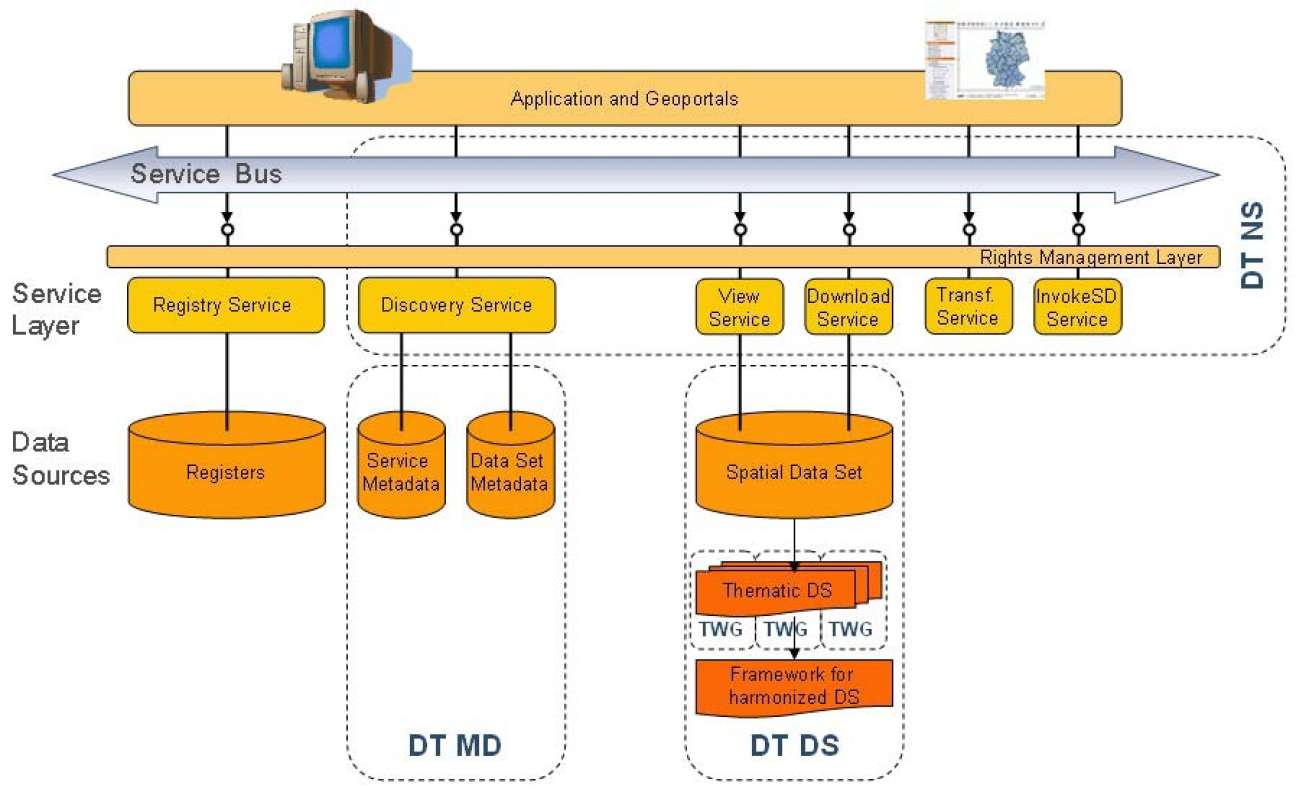
Spatial Data
In principle, every spatial object in a spatial data set needs to be described by a data specification specifying the semantics and the characteristics of the types of spatial objects in the data set. The spatial object types provide a classification of the spatial objects and determine among other information the properties that any spatial object may have (be they thematic, spatial, temporal, a coverage function, etc.) as well as known constraints (e.g. the coordinate reference systems that may be used in spatial data sets). This information is, in principle, captured in an application schema using a conceptual schema language, which is a part of the data specification.
It is important to note that the logical schema of the spatial data set may and will often differ from the specification of the spatial object types in the data specification. In this case, and in the context of real time transformation, a service will transform queries and data between the logical schema of the spatial data set and the published INSPIRE application schema on-the-fly. This transformation can be performed e.g. by the download service offering access to the data set or a separate transformation service.
Metadata
Service metadata provides basic information about a service instance to enable the discovery of spatial data services. The description of a service includes the service type, a description of the operations and their parameters as well as information about the geographic information available from a service offering.
Network Services
Network services are necessary for sharing spatial data between the various levels of public authority in the Community. For these services interoperability is requested by the Directive, which means the possibility for services to interact, without repetitive manual intervention.
It is important to note that for INSPIRE it is assumed that all kind of data and metadata access and processing is performed using web services. All services are described by service descriptions (service metadata, as part of the INSPIRE metadata), allowing humans and software applications to discover specific service instances in the infrastructure and invoke them automatically.
Another view on the INSPIRE Network Services is to see them as a mediator between the services provided by the member states or offered by third parties and their EU-level usage for example via the INSPIRE geo-portal.
MSDI technology solution
The website is mainly installed using open source products and is hosted in the Tier III accredited MITA Data Centre. The portal is running on a virtual environment and uses the Microsoft Windows 2012 as the operating system. A number of open source components that make up the portal include: GeoServer as the main software used for sharing geospatial data, Geonetwork as the catalog application, Geomoose which is used to display distributed cartographic data, Mapserver, Java JRE7 and Apache Tomcat web server.
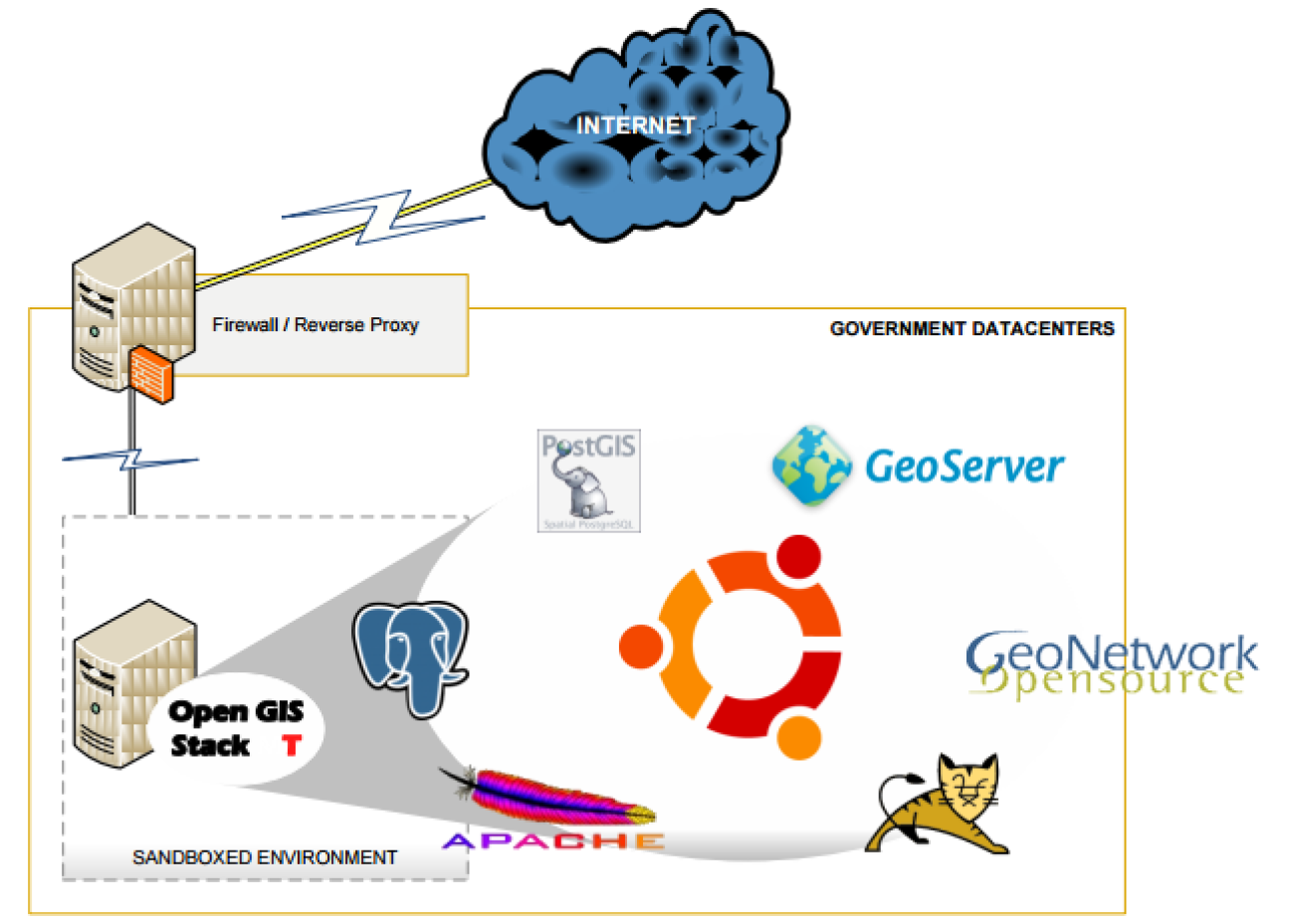
Technology choice: Standards-based technology, Open source software
Main results, benefits and impacts
INSPIRE is based on a number of common principles:
- Data should be collected only once and kept where it can be maintained most effectively.
- It should be possible to combine seamless spatial information from different sources across Europe and share it with many users and applications.
- It should be possible for information collected at one level/scale to be shared with all levels/scales; detailed for thorough investigations, general for strategic purposes.
- Geographic information needed for good governance at all levels should be readily and transparently available.
- Easy to find what geographic information is available, how it can be used to meet a particular need, and under which conditions it can be acquired and used.
The following numbers provide an indicative usage of the platform:
- Number of downloaded datasets: 50
- Number of hits visits: 235,300
Return on investment
Return on investment: Not applicable / Not available
Lessons learnt
Technical
Exposure to open source technologies within the organisation was seen as a challenge due to very limited resources and expertise. but through research, using online available forums and information updates, the initial technical issues were resolved leading to more confidence building in the open source products used.
Data sharing
This service facilitates public service organisations that do not have the necessary infrastructure to host spatial datasets files on the web server and make them available to the general public. In view of this, publicity and marketing of this service were essential to achieve the desired benefits.
MITA also provides Guidelines to facilitate Spatial Data and Service sharing. The document describes, in light of relevant legislation, if there is restriction on access, the use of metadata, transparency on the availability and content of the datasets, response time for providing the datasets, the principle of “emergency datasets” where special attention should be given to major emergencies that have an impact on the environment such as natural disasters and man-made environmental accidents. Other topics addressed in the guideline are IPR, licensing arrangements and charging for datasets and services.
Scope: National