Last update: 13/06/2022
ELISE - European Location Interoperability Solutions for e-Government
eGovernmentGeospatial


The Location Interoperability Framework Observatory (LIFO) monitors the implementation of location interoperability good practices in European public administrations, based on the level of adoption of recommendations in the EULF Blueprint.
The overview of 2020 location interoperability status in France is based on the information provided by Institut National de l'Information Géographique et Forestière (IGN – National Institute of Geographic and Forest Information).
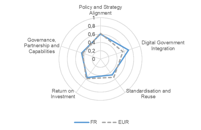
The information obtained through the LIFO 2020 data collection for France indicates an overall location interoperability maturity level, measured through the LIFO index, above the average of the participating countries. This is due to scores above the European averages (and at quite high maturity levels) in the “Digital Government Integration” and “Return on Investment” focus areas.
The three main good practices in the “Digital Government Integration” focus area, where the country obtains the highest score and the widest margin above the European average, are the optimised use of location data in some sectors, the frequent use of SDI to deliver digital public services, and the involvement of external parties when developing or delivering location-based digital public services. On the other hand, there is a low level of implementation maturity of the INSPIRE Directive based on the INSPIRE country fiche.
The country obtains its second highest score in the “Return on Investment” focus area. The two main factors that contributed to this result are the well-established approach to funding the exploitation of public sector reference data and the strategic approach to funding the exploitation of public sector reference data. The assessment of efficiency and effectiveness of location enabled services is on the contrary still not very mature.
The country’s positioning in “Policy and Strategy Alignment” benefits from the availability of a wide range of location core reference datasets and the national licensing framework that regulates the availability of and access to public sector location datasets. The main relative weakness consists in the absence of general cross-sector legislation mandating the use of authoritative (location) datasets in the public sector.
The “Governance, Partnerships and Capabilities” focus area shows a mix of very good and less positive results. Among the former there is the recognised geospatial / public sector ICT or data competency framework that guides the training in geospatial skills. Conversely, the level of coordination between the organisations respectively in charge of the SDI and digital government and the involvement of relevant stakeholders in decision-making on the SDI are still limited. The practice of setting up formal agreements between public authorities to jointly develop and operate location-enabled public services is not well established.
The score below the European average in the “Standardisation and Reuse” focus area is mostly due to the low conformity of spatial data sets and network services to the INSPIRE Directive. There are however positive aspects in this focus area, such as the well-organised approach to monitoring, testing and upscaling of new technological developments and the availability of APIs for all high value location datasets as part of a national strategy.
France has participated also in LIFO 2019. For the 2019 factsheet, click here.
The value of the LIFO index for France combining the scores for all focus areas is 0.56, reflecting an overall maturity profile in line with the European average of 0.55.
For more details, download the factsheet in the attachment section below.
Click here to find out more about the Location Interoperability Framework Observatory (LIFO)
Click here to explore the LIFO 2020 and 2019 results in the LIFO Interactive Dashboards