

The Location Interoperability Framework Observatory (LIFO) monitors the implementation of location interoperability good practices in European public administrations, based on the level of adoption of recommendations in the EULF Blueprint.
The overview of 2020 location interoperability status in Ireland is based on the information provided by Ordnance Survey Ireland.
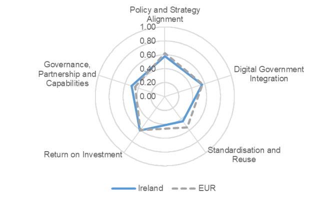
The information collected through the LIFO 2020 data collection indicates that Ireland reaches an overall level of location interoperability equal to the European average.
Ireland obtains the best results in the “Return on investment” focus area. The advantage over the European average is due to the frequent, thorough and convincing communication on the availability and benefits of location data and location-enabled digital public services. Another contribution to this result is given by the extent of the measures taken to make the process of searching, finding and accessing location data and web services as easy as possible. Several actions are implemented to actively support private, non-profit and academic actors in the development of new products, services or research using public sector location data.
Under the “Policy and Strategy Alignment” focus area, Ireland is closely aligned with the European average. A wide range of location core reference datasets are available for general use and location data is available under a national licensing framework. Only generic reference is made to INSPIRE and other relevant standards in public procurements of location information and services.
“Digital Government Integration” is another focus area where Ireland is closely aligned with the European average. There are a good number of cases in Ireland where comprehensive use is made of location information when delivering digital public services and where there is consistent use of the SDI for the development and delivery of digital public services. These good results are counterweighed by the limited use of an open and collaborative methodology when developing and delivering location-enabled digital public services.
As mentioned above, “Standardisation and Reuse” is a relative weakness of Ireland’s location interoperability status compared to the European average. This is due to the lack of a common architectural approach for location data and services in the SDI, the low number of core "high value" location datasets that can be accessed using APIs and the limited scope of its location data quality practices. However, Ireland scores highest on conformity with the INSPIRE regulations of all participating countries.
Finally, the “Governance, Partnerships and Capabilities” focus area shows margins for improvement due to the low involvement of stakeholders in the decision-making process on the role of location information in digital government and to the small number of formal agreements existing between public authorities to finance, build and operate location data services or digital public services using location data.
The value of the overall LIFO index combining the scores for all focus areas is 0.54, almost aligned with the European average of 0.55.

For more details, download the factsheet in the attachment section below.
Click here to find out more about the Location Interoperability Framework Observatory (LIFO)
Click here to explore the LIFO 2020 and 2019 results in the LIFO Interactive Dashboards