Check out the recording and supporting slides for the webinar Evolution of the access to spatial data for environmental purposes – Study presentation
The final report presented in the presentation will be made available here.
If you are interested in knowing more about ELISE Webinars you can find further information here.
Structure of the presentation
- The survey: purpose, methodology and respondents
- Results: Spatial data for environmental purposes
- Results: Spatial data challenges
- Results: Policy impact in spatial data
- Results: Future of SDI – Emerging technologies and trends
- Key take-away messages and conclusions
- Q&A
Recording
Summary of the webinar
Introduction
In the context of the ELISE Action a survey on the ‘Evolution of the access to spatial data for environmental purposes’ was conducted with the objective of obtaining evidence on how the access and use of spatial data has evolved over the last decade. In this survey, data were also collected to have a better understanding on what is the role of spatial data in the environmental reporting activities and what has been the impact of the INSPIRE Directive (2007/2/EC) in this respect.
The survey was primarily targeted at people and organisations making use of spatial data for environmental purposes and in particular at practitioners involved in the preparation of Environmental Impact Assessment (EIA) and Strategic Environmental Assessment (SEA) reports. However, also other stakeholders in the geospatial domain were invited to participate in the survey. The involvement of these different stakeholder groups allowed to investigate the similarities and differences between different users of spatial data.
In this summary report we briefly present the first findings and results of the survey, which also were presented during an ELISE webinar.
Methodology
The survey built further on the 2009 study on the use of spatial data for the preparation of environmental reports in Europe (Craglia et al, 2010). In the study, a survey was undertaken by the Joint Research Centre of the European Commission to find out how easy it is for European Environmental Impact Assessment (EIA) and Strategic Environmental Assessment (SEA) practitioners to obtain the spatial data they need. By repeating the 2009, the current study aimed to collect evidence on how the access and use of spatial data for environmental purposes has evolved over the last decade. In addition to this, the study also aimed to test the relevance and applicability of the 2009 study approach beyond the original scope of EIA/SEA.
Many of the questions included in the 2009 survey were also repeated in the new survey. If possible, the same questions (or very similar questions) were also asked to other stakeholders in the geospatial community. In addition to the original questions, a series of new questions was included in the new survey on the impact of INSPIRE and the future of SDIs/INSPIRE.
The survey was launched in September 2009 and remained open until the end of the year. With support from several key organizations in the domains of environment, geospatial information and interoperability, the survey invitation was disseminated widely in the geospatial community.
The survey was completed by 129 respondents, from more than 20 different countries in Europe. Approximately one third of these respondents (32%) considered themselves as EIA/SEA practitioners. The remaining respondents consisted of environmental practitioners not involved in EIA/SEA (29%) and persons not involved in environmental activities (39%). Looking at the type of organizations these persons were representing, the respondents consisted of a balanced mix of persons from the private sector, government sector and other sectors (NGO, research and non-profit).
In the webinar, the first findings and results were presented around four central topics:
- Spatial data for environmental purposes
- Spatial data challenges
- Policy impact in spatial data
- Future of Spatial Data Infrastructures
In this summary report we highlight some of the key findings related to each of these topics.
Spatial data for environmental purposes
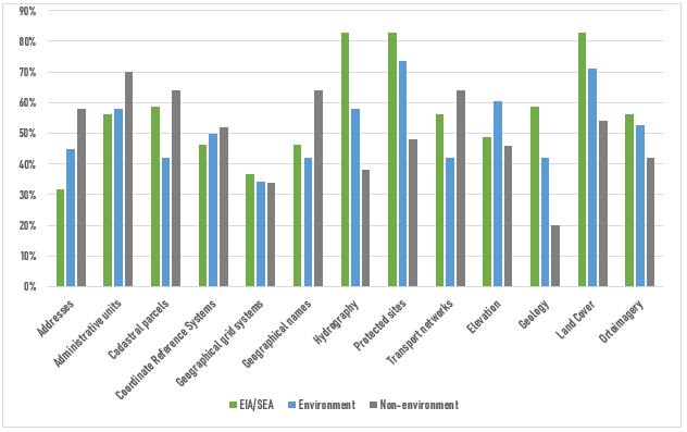
The first set of results presented were related to the spatial data themes most frequently used by the respondents and their organisations. Among the most frequently used data themes were land cover, land use, protected sites, administrative units and hydrography. Focusing on the data themes under Annex 1 and Annex 2 of the INSPIRE Directive, we were able to demonstrate some key differences in the most frequently used data themes by different user groups. The figure below show the differences between EIA/SEA practitioners, environmental practitioners and practitioners not involved in environmental activities with regard to the most commonly used data themes under Annex 1 and Annex 2 of INSPIRE. In a similar way, also differences between private sector practitioners, public sector practitioners and other persons were demonstrated.
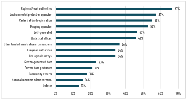
In addition to the most frequently used data themes, evidence was also collected on the most important suppliers of spatial data. Respondents were asked to select the main suppliers of spatial data used by them and their organisation. Looking at the answers provided by the respondents, key providers of spatial data include regional/local authorities, environmental protection agencies, cadastral land registration agencies, mapping agencies and statistical offices. Also important to notice is the importance of self-generated data, but also citizen-generated data and data provided by private organisations.
In the final part of this first section, we had a closer look at the EIA/SEA practitioners, their organization and the way they are making use of spatial data in the preparation of EIA/SEA reports. Among the results presented in the webinar were the types of operations for which EIA/SEA organizations make use of spatial data in the EIA/SEA process. It was shown that spatial data are – extremely – relevant and used for various types of operations, and especially the identification of impacts, the visualisation of impacts and simply analysis and processing tasks.
Spatial data challenges
A second set of key study results and findings focused on challenges and problem in the use of spatial data. We started this section by looking at five main types of – potential – problems in the access and use of spatial data, i.e. problems related to finding data, accessing data, using and integrating data, quality of data and the costs of data. Looking at the answers provided by all respondent groups, the respondents indicated to especially have problems in accessing data (56%), in finding data (54%) and with the quality of data (50%).
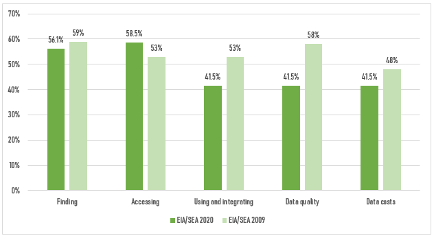
Since this question was also included in the original 2009 survey, we were able to investigate changes in the problems experiences by the 2009 EIA/SEA practitioners and the EIA/SEA practitioners in the current 2020 study. From the results presented in the figure above, it can be seen that nowadays more EIA/SEA practitioners are facing problems in accessing data, while in 2009 more EIA/SEA practitioners indicated to have problems in using and integrating data and with the quality of data.
Further in the survey, more detailed information was collected on the precise problems our respondents were facing when accessing and using data. For each main type of problems – finding, accessing, using, data quality & data costs – a series of specific problems were presented to the respondents, asking them to indicate which problems they were experiences.
The most often experienced problem in finding spatial data are the incomplete or missing descriptions of data (42,6%). Other problems experiences by many of our respondents in finding spatial data are difficulties to know which data are available and the fact that it is not possible to discover data through one single portal.
With regard to accessing spatial data, the most common problems seems to be the fact that access to some datasets is limited or prohibited (42,64%). Other problems that are relevant to a relatively large group of our respondents are the fact that some data are not digitised (25%) and the fact that data cannot be access through web services (25%).
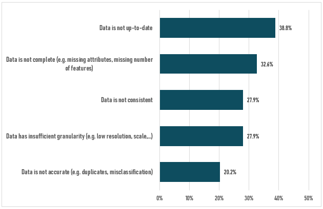
The fact that some data are not up-to-date is the most often experienced problem related to the quality of data. The figure below presents to what extent also other problems with the quality of data are experienced by our respondents. The figure shows that also incomplete data are an often experienced problem by the respondents.
Policy impact in spatial data
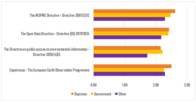
The third set of results were about relevant policies and their impact on the access, use and sharing of spatial data. Respondents were asked to indicate the relevance of various policies and initiatives on making available spatial data, using a using a 4-scale scoring system (none, low, moderate, significant).
Overall, all four policies were considered to be relevant, with the INSPIRE Directive indicated to be the most relevant of the four proposed policies & initiatives. But according to our respondents, also the Open Data Directive, the Directive on public access to environmental information and the Copernicus initiative had a moderate to significant impact on the availability of spatial data. Important to notice is that these impact of these policies and initiatives was assessed differently by different types of respondents. This is illustrated by the figure below, which shows how business practitioners, government practitioners and other stakeholders assess the relevance of the different policies.
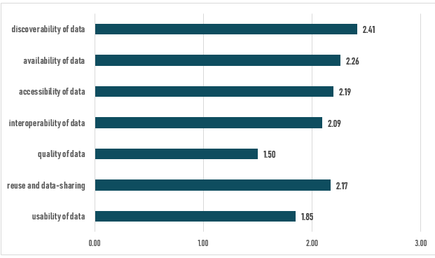
The relevance of the INSPIRE Directive was further investigated, by looking at its precise impact on different aspects. The figure below shows the eight different aspects of using and accessing data on which the INSPIRE Directive could have an impact. Again, respondents were asked to assess the impact using the same 4-scale scoring system. Looking at the answers provided by the respondents, the main impact of INSPIRE is in improving the discoverability of data, the availability of data and the accessibility of data.
Future of Spatial Data Infrastructures
The Future of Spatial Data Infrastructures was explored by looking at two elements: the impact of a emerging technologies and developments in better exploiting spatial data and the relevance and importance of the European Data Strategy and the deployment of common data spaces to suiting the needs of spatial data users.
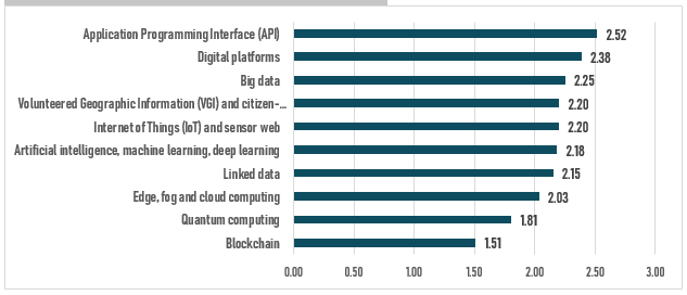
A set of ten emerging technologies and – technological – developments was provided to the respondents, asking them to assess the impact of these on better exploiting spatial data using the 4-scale scoring system. The figure below shows these ten technologies and their impact according to our respondents. Among the technologies with the most significant impact on exploiting spatial data are Application Programming Interfaces (API), digital platforms and big data. Blockchain and quantum computing are considered to be less relevant.
Respondents were asked whether they were aware of the European Data Strategy and its plan to establish a single market for data through the deployment of common European data spaces. A remarkably finding of our study was that less than 28% of our respondents indicated they were aware of the European Data Strategy and the plan to deploy common European data spaces. Respondents were asked to provide suggestions on what the European data market should take into consideration to suit their needs when using and exchanging spatial data. The open answers collected through this questions provided some valuable ideas to take into consideration in the future development of spatial data infrastructures and data spaces.
Key take-away messages and conclusions
In the final part of the presentation some key take-away messages and first conclusions of the study were presented. The survey demonstrated that there still are significant problems in accessing and using data, which have an impact on processes in which these data are used (such as EIA/SEA). The survey also revealed some important differences in the behaviour and opinions of key user groups, such as private sector actors versus government actors or people active in the environmental domain versus other users of geospatial data. When looking at the future of SDIs, it was concluded that the link between these spatial data infrastructure and the new concept of data spaces should be further explored and developed.