Last update: 13/02/2024
LIFO - Location Interoperability Framework Observatory
ObservatorieseGovernmentGeospatial
Return to European State of Play
The Location Interoperability Framework Observatory (LIFO) is a domain-specific observatory relating to location interoperability. It provides a tool to monitor, assess and report on the state of play of location interoperability in policy and digital public services of EU Member States and other countries implementing INSPIRE.
This State of Play Report provides an overview of the information collected on location interoperability from 10 participating countries in 2019 (Austria, Belgium, Czech Republic, Denmark, France, Italy, Norway, Portugal, Slovenia, Slovakia).
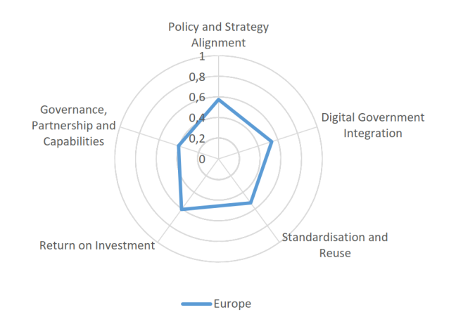
The 2019 European State of Play Report shows that across all the focus areas of the EULF Blueprint most countries offered excellent examples of best practices and that there were a few cases of countries with good scores in all the focus areas. However, overall, the picture also showed many countries with room for improvement.
The “Return on Investment” focus area obtained the highest index score of 0.60, thanks to the quite extensive and diversified measures taken to optimise the investments in location information and solutions and to the quite well-spread promotion of the reuse of existing authentic data, data services, and relevant technical solutions.
It can be inferred from the relatively high value of the index in the “Policy and Strategy Alignment” focus area (0.57) that the participating countries have invested significant resources in implementing location information strategies that are to a greater or lesser extent aligned with digital strategies.
The “Digital Government Integration” area follows suit with an index of 0.54. The potential of location information is partially exploited to bring improvements in digital public services. However, apart from a few exceptions, the potential of location information for breakthrough improvements or innovative approaches to process integration and location-based analytics is not realised yet.
In the “Standardisation and Reuse” area, with an index of 0.54, the level of maturity is twofold. On one side, it is significant in terms of reuse of existing datasets and of the definition of a common architecture for the development of solutions making consistent use of location information. On the other side, improvements in maturity are still to be made in terms of the application of widely acknowledged standards.
The “Governance, Partnerships and Capabilities” focus area was recorded as the lowest score for 2019 data collection with an index score of 0.44, although there are some examples of well-organised approaches in this respect. Significant margins for improvement can be found in the investments in location communications and skills, in the involvement of different stakeholder groups (local administrations, agencies, associations etc.) in decision-making processes on geospatial matters, in the cooperation among digital government agencies and agencies in charge of national SDIs and in the establishment of public-private partnerships or agreements among different public authorities to finance, build, and operate digital public services using location data.
The LIFO index, calculated as the arithmetic average across the five focus area indexes, represents in a concise way the overall level of alignment of the practices implemented by each country across all EULF Blueprint recommendations.
As shown in Figure 2 below, the overall alignment can be grouped in two main country clusters, with exception of the two clear outliers of Czech Republic and Portugal.
The majority of the surveyed countries, excepting the two outliers, is very clearly concentrated in an index maturity range of ±0.13 points from the average, thus demonstrating a relatively homogeneous overall level of maturity across the countries.

For more details, download the factsheet here below in the attachment section.
Click here to know more on Location Interoperability Framework Observatory (LIFO).