Last update: 13/06/2022
ELISE - European Location Interoperability Solutions for e-Government
eGovernmentGeospatial


The Location Interoperability Framework Observatory (LIFO) monitors the implementation of location interoperability good practices in European public administrations, based on the level of adoption of recommendations in the EULF Blueprint.
The overview of 2020 location interoperability status in Czech Republic based on the information provided by Státní správa zeměměřictví a katastru (CUZK - Czech Office for Surveying, Mapping and Cadastre).
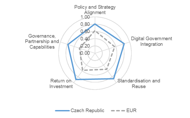
According to the location interoperability state of play identified through the implementation of the EULF Blueprint recommendations, The Czech Republic has performed better than the European averages of 23 surveyed countries in all focus areas .
The Czech Republic has performed better than the European averages of 23 surveyed countries in all focus areas.
“Standardisation and Reuse” is the focus area with the highest score. Examples of strengths are the adoption of a common architecture to develop digital government solutions and the presence of several high value location data sets accessible using APIs. Multilingualism is still a challenge when referring to standards and working documents in foreign languages.
In the “Return on Investment” focus area, the high score is due to the extensive approaches respectively to assessing the efficiency and effectiveness of location-based services and to impact-based improvement in location-enabled processes and services. No policy supporting the reuse of public open data within the public sector and by the private sector has been reported.
“Digital Government Integration” ranks immediately after the first two focus areas. One of the strengths is the comprehensive or even innovative use of location information in many digital public services. Thanks to the integration of authoritative location data (via the Base Registry of Territorial Identification, Addresses and Real Estates, RÚIAN in short ) into the framework of the Base Registries of Czech eGovernment in 2012, the SDI has been used in most cases for the delivery of cross-government digital public services.
In the “Policy and Strategy Alignment” focus area, the location and digital government strategies are strongly aligned. A wide range of core location datasets are available for general use and public procurements of location data and services rely on standards-based architecture references. A relative weakness is the lack of core location datasets fully available without restrictions.
Finally, the “Governance, Partnerships and Capabilities” focus area sees a strong involvement of relevant stakeholders in the decision-making process on the SDI as well as a strongly integrated joint leadership and coordination by the organisations respectively in charge of the SDI and of digital government. A relative weakness is the limited resort to cross-border and public-private partnerships for financing and operating location-enabled digital public services.
Czech Republic has participated also in LIFO 2019. For the 2019 factsheet, click here.
The LIFO index for the Czech Republic combining the scores for all focus areas is 0.84, which represents an excellent performance for the country in terms of location interoperability. This is significantly above the European average LIFO index, which is 0.55.
For more details, download the factsheet in the attachment section below.
Click here to find out more about the Location Interoperability Framework Observatory (LIFO)
Click here to explore the LIFO 2020 and 2019 results in the LIFO Interactive Dashboards