

The Location Interoperability Framework Observatory (LIFO) monitors the implementation of location interoperability good practices in European public administrations, based on the level of adoption of recommendations in the EULF Blueprint.
The overview of 2020 location interoperability status in Austria is based on the information provided by Bundesministerium für Landwirtschaft, Regionen und Tourismus (BMLRT - Federal Ministry of Agriculture, Regions and Tourism) and the Bundesamt für Eich- und Vermessungswesen (BEV - Federal Office of Metrology and Surveying).
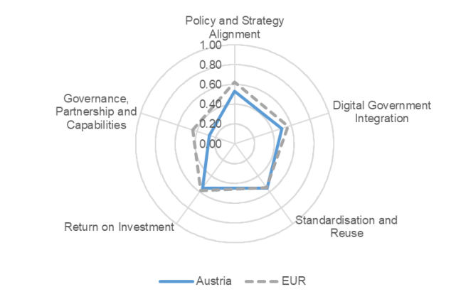
The information collected through the LIFO 2020 data collection indicates that Austria scores below but close to the European averages across the focus areas assessed, with larger gaps under “Governance, Partnerships and Capabilities” and “Policy and Strategy Alignment”
“Return on Investment” is one of the two focus areas where the country reaches the best results, thanks to a good alignment of the practices under the three recommendations with the European averages. Less mature practices concern the application of impact-based improvements in location-enabled processes and services and the support to private and non-governmental actors in the development of new products, services or research using public sector location data.
“Standardisation and Reuse” is the other focus area with the highest score for the country. The positive factors contributing to this result are the reuse of generic ICT solutions in the spatial data infrastructure (SDI) and the high compliance of network services with the relevant INSPIRE implementing regulation. The lack of a common architectural approach for location data and services and the location data quality assurance being limited to the ex-post analysis of quality issues are two significant weaknesses in this area.
Slightly lower is the country’s positioning in the “Policy and Strategy Alignment” focus area. The level of preparedness and awareness in applying all the measures to protect location data privacy is high. Another strength is the use of location information to support policy making in most relevant topics. The lack of a location strategy closely connected with the digital government strategy, however, leads to a significant gap against the European average.
Further below is the score of the “Digital Government Integration” focus area. The integration of location and statistical information in the production of location-based statistics is well developed. The overall implementation maturity of the INSPIRE directive is high. On the other hand, the use of SDIs in digital public services is still basic and the application of a collaborative approach in developing location-enabled digital public services is quite limited.
Finally, the “Governance, Partnership and Capabilities” focus area is where the score is the lowest and the gap with the European average the largest. The weak joint leadership on the role of the SDI in digital public services is a major factor in the country’s low positioning. A positive note is the array of training and awareness-raising initiatives delivered in the geospatial domain.
Austria has participated also in LIFO 2019. For the 2019 factsheet, click here.
The value of the overall LIFO index combining the scores for all focus areas is 0.48, which reflects a number of gaps in Austria's practices in various areas of location interoperability. This compares with a European average of 0.55.

For more details, download the factsheet in the attachment section below.
Click here to find out more about the Location Interoperability Framework Observatory (LIFO)
Click here to explore the LIFO 2020 and 2019 results in the LIFO Interactive Dashboards