Check out the recording and supporting slides for the webinar Geospatially enabled modelling, simulation and prediction
If you are interested in knowing more about ELISE Webinars you can find further information here.
Structure of the presentation
- Introduction
- Modelling, Simulation and Prediction: some definitions
- Modelling: not new to the GIS world
- Zooming in on weather forecasting and agent-based modelling
- Interoperability efforts and challenges
- Key take-away messages and conclusions
- Q&A
Recording
Summary of the webinar
The webinar started with some high-level messages:
- Modelling, simulation and prediction are not new: GIS has always been an advanced technology to model and simulate, but recent developments create new challenges and opportunities.
- Some sectors are more advanced concerning the integration of models, simulations and prediction techniques.
- Specific efforts are needed for reaching interoperability in modelling, simulation and prediction.
The webinar aimed to provide examples showing how many sectors are evolving towards integrating models, simulation and predictive techniques: weather and climate, transport and mobility, health (COVID-19), water and forest management, security and disaster management … and many more.
Section two focused on some key definitions, including the similarities and differences between modelling, simulation and prediction. In the TechTrends mindmap of OGC, two branches are relevant:
- modelling, analysis and prediction and
- simulation and gaming.
Modelling, simulation and prediction are different but interconnected concepts and techniques. “Modelling” is the devising or use of abstract or mathematical models, while “simulation” is the imitation of a situation or process and prediction is the action of predicting something in the future (future state or behaviour).
Besides those three key concepts, there is also “forecasting” that predicts or estimates a future event or trend. Modelling and simulation require interaction with a representation of the real world, while prediction largely depends on user interaction. Moreover, simulation and prediction aim to analyse some phenomenon while modelling establishes the domain of analysis.
Modelling can be done from different perspectives: static, i.e. by describing a quantity that characterises the state of a physical system (Lagrange function) or dynamic, i.e. allowing interactions with the real world according to a pathway (Eulerian trail).
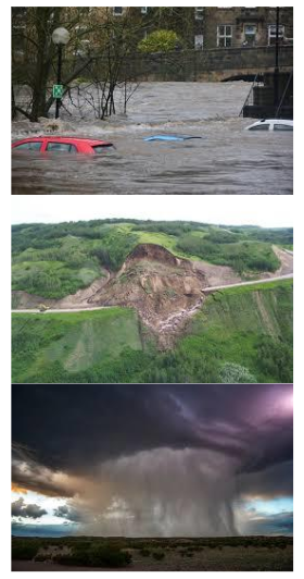
Section three looked back to the past since modelling, simulation and prediction are not entirely new in the geospatial field. A geographic information system (GIS) is a framework for gathering, managing, and analysing data.
Rooted in the science of geography, GIS integrates many types of data. It analyses spatial location and organises layers of information into visualisations using maps and 3D scenes. With this unique capability, GIS reveals deeper insights into data, such as patterns, relationships, and situations—helping users make smarter decisions.
GIS technology emerged in the 70s and evolved gradually into real modelling engines, although GIS and models were still separated (different software). For decades, GIS has been used, such as hydrological and hydraulic modelling for simulating floods and traffic modelling to simulate traffic flows, congestions, etc. In flood modelling, this usually resulted in generating a ‘static’ layer that can then be handled in a GIS to map and analyse with other data. However, this type of modelling has significant limitations:
- GIS and models are still separate – GIS layers, other data (e.g. weather data) are used as input to the model, the output is going back to GIS;
- The need to regularly run the model, with new data, because of new human intervention (e.g. new dykes in case of flood models) and
- From simple ‘models’ (risk assessment based on a DTM) to more complex ones (integrating hydrology, hydraulics …). The simple ones provide limited insights. This type of modelling also required a lot of manual work/interventions.
Some considerations should be made:
- some of the parameters are harder to forecast (e.g. rain);
- the issue of scale is important, and
- The models need to deal with uncertainty.
- Forecasting is more and more following an integrated approach for hazard prediction, monitoring and risk assessment, including potential impacts on the economy/society.
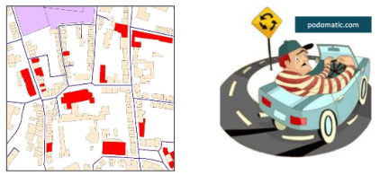
The second example pertains to agent-based modelling in the transportation sector, specifically in traffic management (parking management). Finding parking spaces is a problem almost everywhere in the world. A study in the UK (Daily Mail[1], 2017) found out that drivers spend two days a year trying to find a parking space - and it costs motorists £733 each in time and fuel. In Belgium, SUSTAPARK was set up to develop a method and a tool for providing strategic advice on urban parking planning, evaluation & simulation based on agent-based modelling techniques. The latter refers to simulating actions and interactions of autonomous individuals (agents) in a network to predict the actions of complex phenomena (Dieussaert et al.[2], 2009). Simulation characteristics were as follows:
- One day periods for data collection.
- A temporal resolution of one second.
- A spatial resolution at the level of the street segment.
- A group of agents representing the driver population and agents’ movements based on activity schedules.
The modelling required an ‘intelligent’ road network consisting of geospatial and non-geospatial data. The modelling itself included:
- supply and demand for parking spaces;
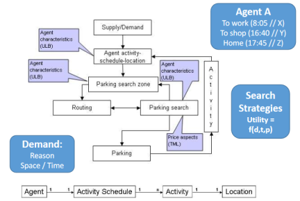
- detailed activity logs of drivers;
- parking search behaviour data, etc.
Agent-Based Modelling in SUSTAPARK has been used, among others, to plan new (central) parking spaces to implement pricing schemes. Other things could be added, such as integrating different transport networks (multi-mode) or ecological parameters.
Section five summarised some of the interoperability challenges. An overview was given of the different Standards Development Organisations (SDO) active in the field. Although the overview was far from complete, it included the OGC with several relevant Domain Working Groups (DWG) currently active:
- Interoperable Simulation and Gaming DWG;
- Meteo & Ocean DWG;
- hydrology DWG …
ISO/TC 204 on Intelligent Transport Systems (ITS) was given as an example for the transport sector. Dedicated standardisation initiatives also exist, such as OpenMI.org. Several OGC standards, such as Web Processing Services (WPS), are used in the context of modelling, while the OpenMI Association is an SDO active in the field of hydraulic and hydrological modelling. As part of GEOSS developments (Earth Observation), the Geo model web initiative was mentioned.
Key messages and conclusions
- The use of modelling, simulation and prediction techniques is not entirely new to the geospatial world; GIS has always been used to analyse, model, and simulate.
- Modelling, simulation and prediction techniques are used in many application domains: climate change, weather forecasting, transport modelling, the spread of pandemic diseases, environmental and water managemen …
- Several geospatial standards are available or under development to support modelling, simulation and prediction activities: OGC and dedicated initiatives exist or have seen the light recently.
There are also challenges:
- There is the growth of vast amounts of data from sensors, satellite imagery …, which provides new opportunities for more advanced MSP; at the same time, this is a challenge.
- Recent technological developments (SWE, IoT, AI …) will make future modelling, simulation and prediction richer and more robust, leading to improved usability.
- Finally, the dedicated initiative to evolve towards a dynamic web of models rather than a web of data/information is promising and should get more attention.
The use of modelling, simulation and prediction techniques is not new to the geospatial world. GIS has always been used to analyse, model, and simulate. However, current environmental, societal, and economic challenges lead to more complex questions to be answered, processed and analysed. Consequently, models, simulators… are becoming more sophisticated as well. They are used in many application domains: climate change monitoring, weather forecasting, transport modelling, the spread of pandemic diseases, environmental and water management… Several geospatial standards are available or under development to support modelling, simulation and prediction activities: OGC and dedicated initiatives exist or have seen the light recently. The vast amounts of data and new technological developments, among others Artificial Intelligence, will help to make the modelling, simulation and prediction even more precise and close to reality. One of the significant challenges raised during the Q&A is how one can deal with the uncertainty aspects: how to measure and communicate them? And, will people using the information coming from the models be able to understand this uncertainty?
[1] The Daily Mail referred to a study by Inrix which was using own surveys and keeps a database with traffic information.
[2] Karel Dieussaert, Koen Aerts, Thérèse Steenberghen, Sven Maerivoet, Karel Spitaels . SUSTAPARK: An agent-based model for simulating parking search, AGILE Conference 2009