On 27 October, ELISE took part in the ‘INSPIRE Conference 2021: Towards a Common European Green Deal data space for environment and sustainability’ with the session on ‘Location Interoperability - Lessons learnt. Where next?’. The session, moderated by Simon Vrečar, external consultant at the European Commission’s Joint Research Centre (JRC), included the speakers Francesco Pignatelli, ELISE action leader, Ray Boguslawski, external expert and Lorena Hernández, project officer at the European Commission’s Joint Research Centre (JRC); Miguel Alvarez, Georges Lobo and Victoria Kalogirou programme managers at the European Commission’s Directorate-General for Informatics (DIGIT); CheeHai Teo, senior advisor at the United Nations Secretariat for Global Geospatial Information Management (UN-GGIM); Morten Borrebaek, chief engineer at Kartverket (Norwegian Mapping Authority); and Massimo Pedroli, senior consultant at Deloitte.
The INSPIRE CONFERENCE 2021 was held from 25 to 29 October. Under the title ‘Towards a Common European Green Deal data space for environment and sustainability’, the conference held 13 sessions to investigate the implementation of the INSPIRE Directive and the way towards a common European space for green open data to meet the objectives of the Green Deal.
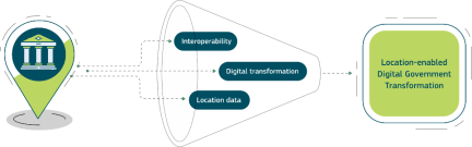
The session revealed lessons learnt by the ELISE action to foster location interoperability in digital public service delivery and highlighted future actions related to European digital and data policy.
ELISE for location interoperability
The first part of the session showcased the activities and results achieved by ELISE to foster location interoperability in digital public service delivery. Francesco Pignatelli presented the results achieved by ELISE in these years. Since the launch of the action in 2016, ELISE:
- published 41 studies;
- set a framework for using location information in policy and digital public services;
- developed 11 solutions and 6 applications;
- hosted 52 webinars and 22 workshops.
ELISE significantly contributed to put the INSPIRE Directive into practice with specific tools for data providers, such as the Reference Validator and Re3gistry and boosting the creation of a European Union spatial data infrastructure.
Ray Boguslawski highlighted the role and evolution of the EULF blueprint to use location information in digital public services, remarking the importance of location aspects in policies and strategic digital frameworks. First published in 2017, the EULF blueprint has evolved in the following years with periodical updates to respond to the new needs linked to the geospatial interoperability domain.
The latest EULF blueprint version includes a renewed benefits guidance and updates to align the guidance with the current European policy context. Moreover, the 2021 version includes inputs from the 2020 LIFO run.
Massimo Pedroli presented the role of LIFO, based on the EULF blueprint recommendations, to monitor the alignment to location interoperability good practices in Europe. As a result, LIFO’s 2020 results show an overall improvement against the previous year for participating countries. In particular, Policy and Strategy Alignment is the area which recorded the greatest improvement, while ‘Governance, Partnerships and Capabilities’ recorded the lowest one. Together with the EULF blueprint recommendations, LIFO’s monitoring mechanism provide sustainable support to the Member States in achieving location interoperability for the better digital public services delivery.

Georges Lobo and Victoria Kalogirou showcased how the Interoperability Academy is strictly linked to the activities carried out by ELISE Knowledge Transfer activities in promoting interoperability in digital public services. The purpose is to increase the adoption of ISA2 and CEF solutions and develop the skills needed to achieve interoperable cross-border and cross-sector public services.
Since 2019, the Interoperability Academy offers a variety of activities such as live events (workshops, webinars, seasonal schools, trainings) and self-paced courses in the area of interoperability to support policy, service delivery and impact evaluation.
Different perspectives and future directions for location interoperability
The session also remarked how location interoperability is pursued at different levels. CheeHai Teo presented the Integrated Geospatial Information Framework (IGIF) developed by UN-GGIM. The framework provides a basis and a guide for developing, integrating, strengthening and maximising geospatial information management and related resources in all countries.
The IGIF presents cross-references with the EULF Blueprint, giving a complementary perspective on strategic pathways and recommendations to foster the use of geospatial data.
Some attendees supported deeper alignment between the IGIF and the EULF Blueprint.
Miguel Alvarez showcased the main findings of the European Interoperability Framework (EIF) and its future paths.
Since its launch in 2004, The EIF has provided high-level advice and guidance to the creation of interoperability digital public services for the Member States. However, challenges will still need to be faced to improve the framework, such as providing practical guidance to support the implementation of the framework and increasing the level of knowledge and awareness of the framework at the regional and local.
In concluding the session, Francesco Pignatelli highlighted the increasing importance of location interoperability in the future of the EU policy context. In this regard, a closer engagement between digital government actors and the private sector users will significantly accelerate the adoption of location interoperability in digital public service delivery. As the ELISE action will end this year, the new European Location Intelligence and Technological Enablers (ELITE) action will continue the activities carried out and expand their range with new ones related to sandboxing and data spaces cookbook.
Main take-aways of the session:
- The EULF blueprint recommendations, together with LIFO’s monitoring mechanism, provide sustainable support to the Member States in achieving location interoperability for better digital public services delivery
- Location aspects play an important role in the development of policices and strategic digital frameworks
- Knowledge Transfer support is crucial to better exploit ‘location’ assets in the new policy landscape for all types of stakeholders
- Preserving the community dealing with location interoperability will assure better knowledge sharing among the stakeholders and increase their skills and competencies
- Closer engagement between digital government and private sector users across all levels of society will help to raise the game in achieving location interoperability in digital public service delivery
Slides and Recording
Check out the recording and supporting slides of the session.
If you are interested in knowing more about ELISE Webinars you can find further information here.
RECORDING WILL BE AVAILABLE SOON